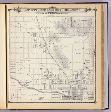
Historical cartography offers invaluable insights into the development of regions and the evolution of land ownership. Among the treasures of the David Rumsey Historical Map Collection is a detailed map from 1892 showcasing the Pioneer Land Company subdivisions in Tulare County, California. This meticulously crafted map, originally compiled, drawn, and published by Thos. H. Thompson of Tulare, provides a fascinating glimpse into the late 19th-century landscape of this Californian county.
 1892 Map of Pioneer Land Company Subdivisions in Tulare County, California
This historical map, part of the renowned David Rumsey Map Collection, is not just a visual representation; it’s a document of record. Created in 1892, the “Map of Pioneer Land Co.’s subdivisions, Tulare Co., California” offers a detailed look at land parcels and subdivisions managed by the Pioneer Land Company. The map extends its reach to include a portion of Porterville, offering geographical context and highlighting areas of development at the time.
Thos. H. Thompson, the author and publisher, ensured the map was rich in detail. Relief is indicated using hachures, a technique common in historical maps to represent terrain. Beyond topography, the map meticulously marks sections, subdivisions, and even identifies owners of large land parcels. This level of detail makes it an invaluable resource for researchers interested in land history, genealogy, and the economic development of Tulare County during this era.
Published within Thompson’s “Official historical atlas map of Tulare County” in 1892, this map is more than just a standalone piece. It’s part of a broader historical record, offering a snapshot of the region as documented in the late 19th century. Its inclusion in the David Rumsey Map Collection ensures its preservation and accessibility for future generations interested in understanding the legacy of companies like Pioneer Land Company and their impact on the Californian landscape.
For those interested in delving deeper into historical cartography and the specifics of Tulare County’s past, exploring this map within the David Rumsey Collection offers a rich and detailed journey back in time, illuminating the role of the Pioneer Land Company in shaping the region.