Satellite imaging technology is revolutionizing how we view and interact with our planet, and pioneer-technology.com is your premier source for understanding these advancements. This technology offers solutions across various sectors by providing detailed insights and data-driven solutions. Delve into the world of remote sensing and discover how satellite imaging is shaping our future with us today.
1. How Does Satellite Imaging Improve Agricultural Practices?
Satellite imaging greatly enhances agricultural practices by offering detailed insights into crop health, soil conditions, and irrigation needs. This technology enables farmers and agricultural policymakers to make data-driven decisions, leading to increased productivity and efficient resource management.
Satellite imaging offers a comprehensive view of agricultural lands, making it simpler to monitor crop development, detect drought, and assess snow cover. According to research from the University of California, Davis, the use of satellite data for rainfall assessments helps farmers accurately time irrigation and seeding. This leads to more precise predictions about a region’s agricultural output. Satellite imagery also allows for the early detection of crop diseases and pest infestations, enabling timely interventions and minimizing potential losses. This technology provides invaluable data to optimize agricultural practices, ensuring food security and sustainable farming.
2. In What Ways Does Satellite Imaging Aid Wildlife Conservation Efforts?
Satellite imaging plays a pivotal role in wildlife conservation by providing researchers and scientists with high-resolution imagery for tracking endangered species, mapping habitats, and monitoring migration patterns. This technology significantly enhances geospatial data collection, supporting effective conservation and management activities.
By using satellite imagery, conservationists can monitor remote areas and gain insights into the behavior and habitats of various species. According to a study published in the journal Remote Sensing of Environment, satellite data assists in identifying and tracking wildlife corridors, which are vital for maintaining genetic diversity. Moreover, it helps in detecting and monitoring illegal activities like poaching and deforestation, enabling timely intervention and protection of endangered species. The detailed imagery allows for the creation of accurate habitat maps, which are essential for planning conservation strategies and managing wildlife populations effectively.
3. How Is Satellite Imaging Technology Used in Risk Assessment and Disaster Management?
Satellite imaging is an invaluable tool in risk assessment and disaster management, providing regional planners with essential data for mapping various types of disasters. The high-resolution imagery enables effective damage estimation and emergency management, facilitating quicker and more informed responses to crises.
With satellite imaging, authorities can rapidly obtain data over wide areas, which is crucial for assessing the impact of natural disasters such as volcanic eruptions, tsunamis, fires, floods, hurricanes, and earthquakes. A report by the United Nations Office for Disaster Risk Reduction highlights that satellite data is essential for identifying potential natural disasters, helping to save lives by enabling early warnings and evacuations. The ability to distribute images of immediate aftermath globally ensures that aid and resources can be directed to the areas most in need, optimizing disaster recovery efforts.
 Disaster-risk areas are highlighted in orange and yellow
4. What Contributions Does Satellite Imaging Make to the Study of Urban Geography?
Satellite imaging is an effective technology for monitoring and mapping environmental changes and urban growth, making significant contributions to the study of urban geography. Its synoptic and repetitive coverage allows for the detailed study of metropolitan areas, aiding in urban environmental impact assessment, monitoring urban growth, and detecting changes in land cover and land use.
By integrating satellite imagery with GIS (Geographic Information System), researchers can gain a better understanding of urban ecosystems and their interactions. Research from the Lincoln Institute of Land Policy indicates that satellite data helps detect changes over time, providing valuable insights into urban expansion and its effects on the surrounding environment. This technology supports informed urban planning and sustainable development by offering a comprehensive view of urban dynamics and their impact on resources and infrastructure.
5. How Does Satellite Imaging Assist in Managing and Recovering from Disasters?
Satellite imaging significantly aids in managing and recovering from disasters by assisting in risk reduction initiatives and verifying hazard models. It provides meteorologists with the imagery needed to issue warnings of potentially deadly weather conditions, enabling emergency responders and the public to make informed decisions.
Remote sensing technology has been successfully used to identify hazard zones associated with active faults, coastal inundation, and flood plains. Data from the National Oceanic and Atmospheric Administration (NOAA) shows that satellite imagery provides critical information for measuring the magnitude and location of actual events, which helps in verifying hazard models and improving predictive capabilities. This technology also allows for the sharing of image processing data on the Internet, making it accessible worldwide and fostering collaborative disaster response efforts.
6. How Is Satellite Imaging Used for Image Classification in Urban Expansion?
Satellite imaging is crucial for image classification in urban expansion, allowing for the monitoring and detection of urban areas that emerge due to continuous urbanization. This capability is essential for understanding the influence of urban expansion on the surrounding environment and ecosystem, aiding in urban planning and addressing socio-economic problems.
Compared to conventional mapping methods, satellite imagery offers advantages like broader coverage, efficiency, and convenience. According to the American Society for Photogrammetry and Remote Sensing (ASPRS), satellite data provides a reliable and up-to-date overview of urban development, facilitating the creation of effective urban management strategies. This technology supports sustainable urban growth by providing the necessary data for balancing development with environmental preservation.
7. In What Ways Does Satellite Imaging Optimize Solar Panel Energy Output?
Satellite imaging optimizes solar panel energy output by aiding in the monitoring and improvement of energy efficiency. By providing reliable and updated data, this technology helps understand and monitor energy infrastructure, analyze markets, and reduce potentially damaging events.
Remote sensing imagery is an important tool for analyzing energy infrastructure. Research published in Solar Energy journal demonstrates that satellite data can identify the optimal locations for solar panel installations by assessing solar irradiance and potential shading. This ensures maximum energy output and efficiency. Additionally, it helps in monitoring the performance of existing solar farms, detecting anomalies, and predicting maintenance needs, thus ensuring the long-term reliability and productivity of solar energy systems.
8. How Does the Shuttle Radar Topography Mission (SRTM) Use Satellite Imaging to Study Earth’s Surface Elevation?
The Shuttle Radar Topography Mission (SRTM), an international project by NASA and NIMA, uses satellite imaging to obtain digital elevation imagery and generate a digital topographic database of the Earth. This data is primarily used for geographic information systems and is accessible via the Internet, helping to understand elevations in specific areas.
The SRTM data provides a high-resolution topographic map of the Earth’s landmass, enabling detailed analysis of surface elevations. According to NASA, this data has numerous applications, including mapping floodplains, improving navigation safety, and supporting scientific studies in fields like hydrology and geology. The availability of SRTM data has greatly enhanced our understanding of Earth’s topography and its impact on various environmental processes.
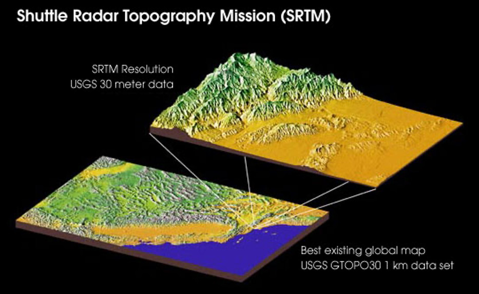 High-resolution topographic map of the Earth
9. How Can Satellite Imaging Observe and Analyze the Growth of Urban Populations?
Satellite imaging is a time-efficient method for analyzing population dynamics, especially in larger cities and townships. This technology provides reliable data on population distribution and growth, which is essential for creating appropriate plans and policies to address development while minimizing environmental impact.
By using satellite imagery, urban planners can gain insights into population density, land use patterns, and infrastructure development. The United Nations Population Fund (UNFPA) emphasizes that satellite data is invaluable for monitoring urban expansion and identifying areas with rapid population growth. This information helps in allocating resources effectively, planning public services, and addressing socio-economic challenges associated with urbanization. The ability to analyze population dynamics through satellite imaging supports sustainable development and improved quality of life in urban areas.
10. What Emerging Trends Are Expected in Satellite Imaging Technology?
Several emerging trends are expected in satellite imaging technology, including the development of more advanced sensors, increased data processing capabilities, and the integration of artificial intelligence (AI) for enhanced analysis. These trends promise to expand the applications of satellite imaging and provide even more detailed and accurate insights.
One significant trend is the development of hyperspectral imaging, which captures data across a wide range of the electromagnetic spectrum, providing detailed information about the composition and condition of surfaces. According to a report by Market Research Future, the integration of AI and machine learning algorithms is enabling automated analysis of satellite data, accelerating the extraction of valuable insights and improving decision-making processes. Additionally, the miniaturization of satellite technology is leading to the deployment of more affordable and accessible satellite systems, fostering greater innovation and utilization of satellite imagery across various sectors.
Different Applications of Remote Sensing Satellite Imagery Data
Remote sensing satellites orbit the Earth at regular intervals, recording and providing real-time data. This data allows for historical analysis and current state assessments, forming the basis for scientific research and facilitating daily activities in diverse aspects of life.
Improving Agriculture via Remote Sensing Satellite Imagery
Climate changes, weather extremes, water availability, and soil conditions pose significant challenges for farmers worldwide. Space-based technology offers immense value to agricultural policymakers, food manufacturers, agronomists, and farmers aiming to boost productivity and profits.
One crucial application of satellite imagery is to gather critical data for monitoring crop development, drought conditions, snow cover, and soil health. Rainfall assessments from these satellites aid farmers in determining the optimal timing for irrigation and seeding, while also providing accurate predictions about agricultural output. This data-driven approach enhances farming practices and ensures better yields.
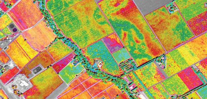 Remote sensor imagery of a typical farm
Saving Wildlife
Advancements in technology have expanded opportunities to collect and analyze data for wildlife monitoring and assessment, with satellite remote sensing playing a crucial role. High-resolution imagery provides researchers and scientists with increased geospatial data, enabling accurate tracking of endangered species in remote areas, mapping habitats, and monitoring migration patterns. This significantly supports conservation and management efforts.
Remote sensing imagery technology has been instrumental for conservationists and animal experts. Wildlife faces constant threats from poaching, deforestation, and habitat loss. As many species are categorized as endangered, these imageries assist in maintaining track and monitoring wildlife, fostering better protection strategies.
Assessing Risk
Remote sensing is an essential tool for regional planners. Beyond general planning, satellite images prove invaluable for mapping various types of disasters. High-resolution imagery has opened new possibilities in risk estimation, mitigation, and management.
Obtaining data of a wide area in a short time is beneficial for effective damage estimation and emergency management. The images of the immediate aftermath of disasters like volcanic eruptions, tsunamis, fires, floods, hurricanes, and earthquakes are distributed globally, helping to identify potential natural disasters and save lives.
Studying Urban Geography
Remote sensing imagery is hailed as one of the most effective technologies for monitoring and mapping environmental changes and urban growth. The synoptic and repetitive coverage aids in studying different metropolitan areas, providing a base for urban environmental impact assessment, monitoring urban growth, detecting urban change, land cover distribution, and land use.
With satellite imagery in remote sensing, critical components of typical urban ecosystems and interactions within urban environments can be understood. Incorporated with GIS (Geographic Information System), remote sensing technology offers better opportunities for detecting changes over time with ease.
Managing Disaster Recovery
Remote sensing technology has proven its worth in disaster management, assisting risk reduction initiatives by identifying hazard zones associated with active faults, coastal inundation, and flood plains. By measuring the magnitude of actual events and their location, hazard models can be verified.
Meteorologists use imagery to provide warnings of potentially deadly weather conditions. The technology provides emergency responders and the public with crucial information for immediate decisions. Remote sensing satellite image processing data can also be shared on the Internet, benefiting viewers worldwide.
Image Classification For Urban Expansion
Mapping urban forms at local and regional scales is essential for studying urban expansion’s influence on the surrounding environment and the overall ecosystem. Remote sensing imagery is used to monitor and detect urban areas that spring up due to incessant urbanization. This is important due to its influence on urban planning and socio-economic problems. Remote sensing imagery provides advantages like coverage, efficiency, and convenience compared to conventional mapping methods.
Solar Panel Energy Output Optimization
The world stands at the crossroads between fossil fuels and renewable energy, with increasing concerns about environmental safety. New types of remote sensing satellite imagery techniques and tools are developed to aid and monitor energy efficiency more effectively. This requires reliable and updated data.
Remote sensing imagery is a crucial tool in this effort. Even in the most pressing challenges, this data helps understand and monitor energy infrastructure. Besides analyzing markets, it can also reduce potentially damaging events.
Generating and Studying Earth’s Surface Elevation Via Shuttle Radar Topography Mission
The SRTM (Shuttle Radar Topography Mission) is an international project of NASA and NIMA (National Imagery and Mapping Agency). It aims to obtain digital elevation imagery and generate a digital topographic database of the Earth. This data is primarily used for geographic information systems and can be downloaded via the Internet. Overall, this data provides elevation insights in any particular area.
Observing The Growth of Urban Population
Population growth is a dynamic phenomenon that affects the natural environment. It raises questions about how to address development while minimizing environmental impact. Adequate data and knowledge about population dynamics are necessary to create appropriate plans and policies.
Remote sensing satellite imagery offers a time-efficient way to analyze population, especially in larger cities/townships. This method has been used for many years and provides reliable data, giving an idea about the population in an area to plan accordingly.
The Future of Satellite Imaging Technology
The future of satellite imaging technology is bright, with ongoing advancements promising more detailed and accurate data for a wide range of applications. These include the development of more sophisticated sensors, improved data processing capabilities, and the integration of artificial intelligence (AI) for enhanced analysis.
Here is a table summarizing the upcoming trends and their potential impact:
| Trend | Description | Potential Impact |
|---|---|---|
| Hyperspectral Imaging | Captures data across a wide range of the electromagnetic spectrum. | Provides detailed information about the composition and condition of surfaces, enhancing accuracy in various applications. |
| AI and Machine Learning | Enables automated analysis of satellite data. | Accelerates the extraction of valuable insights and improves decision-making processes. |
| Miniaturization | Leads to the deployment of more affordable and accessible satellite systems. | Fosters greater innovation and utilization of satellite imagery across various sectors. |
| Enhanced Resolution | Development of sensors with higher spatial, spectral, and temporal resolution. | Enables more detailed and timely monitoring of environmental changes and human activities. |
| Edge Computing | Processing of satellite data on board the satellite. | Reduces latency and bandwidth requirements, allowing for real-time analysis and faster response times. |
| Integration with IoT | Combining satellite data with data from Internet of Things (IoT) devices. | Provides a more comprehensive view of the environment and enables new applications in areas such as precision agriculture |
To discover more about the latest trends and applications in satellite imaging technology, visit pioneer-technology.com.
FAQ: Satellite Imaging Technology
1. What is satellite imaging technology?
Satellite imaging technology involves using satellites equipped with specialized sensors to capture images of the Earth’s surface. These images provide detailed information about various features, including land cover, vegetation, urban areas, and natural phenomena.
2. How does satellite imaging differ from aerial photography?
Satellite imaging covers larger areas and provides more frequent data compared to aerial photography. Satellites orbit the Earth at regular intervals, offering consistent and repetitive coverage, while aerial photography is typically limited to specific areas and timeframes.
3. What are the main types of sensors used in satellite imaging?
The main types of sensors include optical sensors, which capture visible and infrared light, and radar sensors, which use radio waves to create images. Optical sensors are useful for observing land cover and vegetation, while radar sensors can penetrate clouds and provide data in all weather conditions.
4. How is satellite data processed and analyzed?
Satellite data is processed using specialized software to correct for distortions and atmospheric effects. The data is then analyzed using various techniques, including image classification, spectral analysis, and change detection, to extract meaningful information.
5. What are the limitations of satellite imaging?
Limitations include cloud cover, which can obstruct optical sensors, and the spatial resolution of the images, which may not be sufficient for some applications. Additionally, the cost of acquiring and processing satellite data can be a barrier for some users.
6. How can satellite imaging contribute to climate change monitoring?
Satellite imaging is used to monitor changes in ice cover, sea levels, and vegetation patterns, providing valuable data for understanding and addressing the impacts of climate change. It also helps in tracking deforestation and monitoring carbon emissions.
7. What are the ethical considerations associated with satellite imaging?
Ethical considerations include privacy concerns related to high-resolution imagery and the potential for misuse of the data. It is important to ensure that satellite data is used responsibly and ethically, with respect for individual privacy and data security.
8. How is satellite imaging used in urban planning and development?
Satellite imaging provides valuable data for urban planning and development by monitoring urban growth, identifying suitable locations for infrastructure, and assessing the environmental impact of urban areas. It helps in creating sustainable and efficient urban environments.
9. What are the emerging trends in satellite imaging technology?
Emerging trends include the development of hyperspectral imaging, the integration of AI for automated data analysis, and the miniaturization of satellite technology. These advancements promise to expand the applications of satellite imaging and provide more detailed and accurate insights.
10. Where can I learn more about satellite imaging technology?
You can learn more about satellite imaging technology by visiting pioneer-technology.com, which offers detailed articles, expert analyses, and the latest updates on this rapidly evolving field. Pioneer-technology.com is your go-to resource for understanding and exploring the world of remote sensing and satellite imagery.
Remote sensing satellite imagery is essential for analyzing population, especially in larger cities/townships. This method, used for years, provides reliable data to plan effectively.
What innovations in satellite imaging excite you most? Join the discussion at pioneer-technology.com, and let’s explore the future of this groundbreaking technology together.
Address: 450 Serra Mall, Stanford, CA 94305, United States
Phone: +1 (650) 723-2300
Website: pioneer-technology.com
For those eager to dive deeper and remain ahead of the curve regarding technological advancements, we cordially invite you to visit pioneer-technology.com. Explore our comprehensive articles, gain insights from expert analyses, and stay informed with the most recent updates in the ever-changing world of pioneering technology. Don’t miss the opportunity to enrich your understanding and connect with the innovations shaping our future. Visit us now and discover the transformative potential that awaits!